
UNITED STATES — After a brutally cold two-week stretch across large parts of the country, a major pattern flip is expected next week, with forecast guidance pointing to widespread above-average temperatures and highs climbing back into the 70s across much of the South. The warm-up appears broad, with milder air expanding across the Plains, Midwest, Great Lakes, Southeast and portions of the East.
Above-Average Temperatures Expand Across Multiple Regions
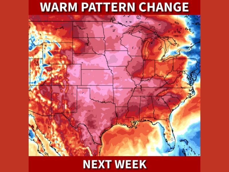
A temperature anomaly map shows warm air spreading across a large portion of the continental United States, with the strongest warm departures centered over the eastern half of the country. The signal includes much of the Midwest, the Ohio Valley, the Great Lakes, the Tennessee Valley, and the Southeast, suggesting a more sustained break from the cold rather than a brief one- or two-day bounce.
Even areas that have seen repeated cold shots in recent weeks appear set to trend milder as the jet stream configuration shifts.
South Expected to See Widespread Highs in the 70s
Forecasters are specifically calling out a return to 70-degree highs across the South next week. That includes a broad stretch from parts of Texas and the Gulf Coast into the Deep South and portions of the Southeast, where above-average temperatures are expected to dominate.
For many communities, this would mark a sharp reversal from the recent cold stretch, especially in areas that experienced hard freezes and repeated cold-front reinforcements.
No Major Cold Snaps Showing Up Over the Next 7 to 10 Days
The outlook included a notable statement that there are no big cold snaps currently showing up over the next 7 to 10 days. While smaller day-to-day fluctuations are still possible, the overall trajectory favors a warmer regime holding in place rather than an immediate return to a winter blast.
This can also shift precipitation types in many regions, reducing snow chances in the South and increasing the likelihood of rain events instead.
What This Pattern Flip Could Mean for Late-Week Planning
A warmer pattern can bring a quick thaw in areas that recently picked up ice or snow, but it can also create water runoff issues when temperatures rise rapidly. In the South, it often means a return to springlike afternoons, but mornings may still start cool, especially in sheltered inland areas.
Forecasters will continue tracking how long the warm regime lasts and whether another colder push develops later, but next week’s signal remains strongly tilted toward above-average temperatures.
For continued updates on national pattern changes and what they mean locally, follow weather coverage at WingsPNW.com.
Leave a Reply