
FLORIDA — A Tampa Bay meteorologist is drawing attention after a 7-day forecast that included a snow icon ended up lining up with reality, as a late-week cold blast brought rare snowflakes to parts of the Sunshine State and sent temperatures sliding sharply over the weekend.
Forecaster Says the Snow Call Was Made Days Before the Cold Blast
In a social media post, the meteorologist said the station’s seven-day outlook was posted last Wednesday — three days before the coldest push of the week — and included a snow signal that many viewers doubted at the time. The forecaster described hearing skepticism from both viewers and other meteorologists, but said the atmosphere ultimately delivered “a few snowflakes” anyway.
The post framed the moment as a reminder that winter patterns can surprise even in Florida, especially when cold air dives deep enough into the peninsula.
7-Day Forecast Shows Weekend Temperature Drop With Snow Icon
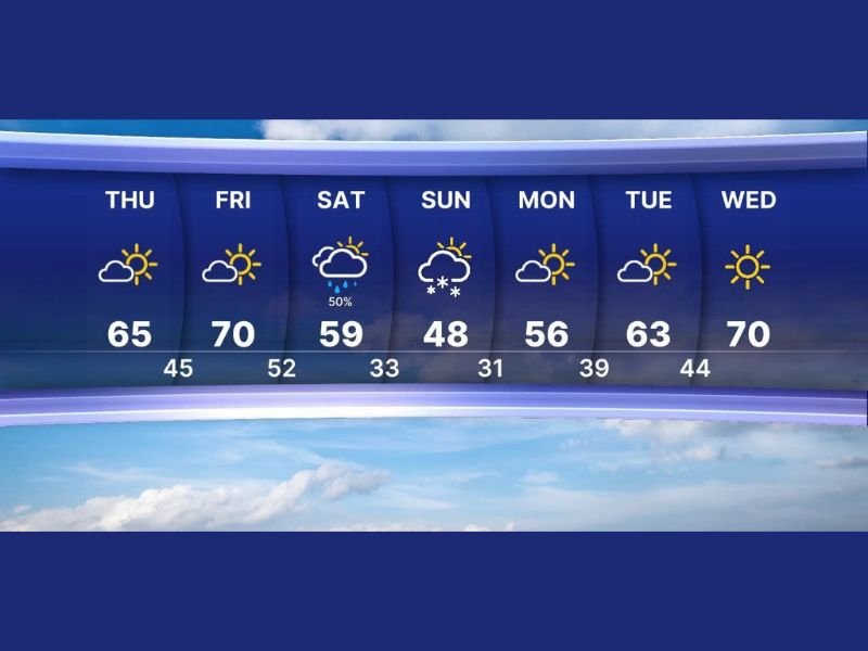
The forecast graphic shows a notable warm-to-cold swing across the Tampa Bay area. Highs were projected in the mid-60s to around 70 late week before falling into the 50s and then the upper 40s, with the snow icon appearing on the colder day.
The seven-day panel displayed these highs and lows:
Thursday: 65 / 45
Friday: 70 / 52
Saturday: 59 / 33 with rain chance shown
Sunday: 48 / 31 with a snow symbol
Monday: 56 / 39
Tuesday: 63 / 44
Wednesday: 70 with sun shown
The overnight lows near freezing highlighted how unusually cold the air mass was for Florida standards.
Why Florida Can See Snowflakes Even When Accumulation Is Unlikely
Meteorologists note that Florida snow events are typically brief and localized because surface temperatures and ground warmth usually limit accumulation. But when cold air is deep enough and moisture arrives at the right time, flakes can mix in, especially during the overnight and early morning hours when temperatures bottom out.
The Tampa Bay forecast suggests that the key ingredients were present during the coldest part of the weekend, allowing at least some areas to briefly see wintry precipitation.
A Reminder of How Fast Winter Patterns Can Shift
The larger takeaway from the forecast discussion is the speed of the temperature change. A forecast that starts with highs near 70 and ends with near-freezing mornings can create sudden travel and safety issues, including icy bridges in rare cases and higher risk for cold exposure for vulnerable residents.
While most of the region remained dry and sunny outside of the cold blast window, the meteorologist said correctly flagging the potential for snow so far in advance was a rewarding moment — and proof that sometimes even Florida can get a quick taste of winter.
For more weather coverage and major pattern shifts impacting the U.S., stay with WingsPNW.com.
Leave a Reply