
UNITED STATES — The National Weather Service has released a preliminary snowfall totals map for the winter storm that began early Saturday morning, January 31, 2026, and continued into Sunday, February 1, revealing widespread moderate to heavy snow across North Carolina, South Carolina, and parts of northeast Georgia.
The map remains subject to revision, as additional snowfall reports continue to be collected from trained spotters, emergency officials, and public observers across the region.
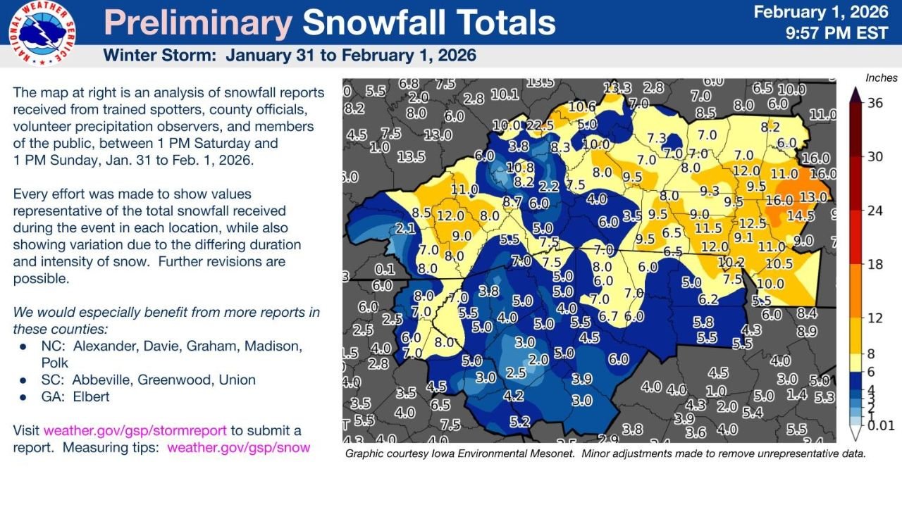
Heaviest Snowfall Focused Across Central and Western North Carolina
According to the preliminary analysis, large portions of central and western North Carolina experienced some of the highest snowfall totals from the storm.
Reported totals across North Carolina include:
- 8 to 12 inches across parts of the central Piedmont
- 10 to 13 inches in localized higher-elevation areas
- 6 to 9 inches extending eastward toward central counties
Several counties in the northern and central sections of the state show double-digit snowfall, highlighting the intensity and duration of the event.
Significant Snowfall Extends Into Upstate South Carolina
Snowfall also spread well into upstate South Carolina, where totals were lower than in North Carolina but still impactful.
Preliminary totals indicate:
- 5 to 8 inches across much of the upstate
- 3 to 6 inches in southern and southeastern upstate counties
- Locally higher amounts near the North Carolina border
The snowfall created rare winter storm conditions for many South Carolina communities that typically see limited snow accumulation.
Northeast Georgia Also Impacted by the Storm
The map shows lighter but notable accumulations across northeast Georgia, particularly in counties closer to the Carolinas.
Snow totals in Georgia generally ranged from:
- 2 to 5 inches in northeast sections
- Lower amounts farther south and west where precipitation tapered off
Preliminary Data Still Being Refined
The National Weather Service notes that:
- The map represents snowfall between 1 PM Saturday and 1 PM Sunday
- Totals are based on trained spotters, county officials, volunteer observers, and public reports
- Further revisions are possible as new reports are reviewed
Additional snowfall data is still being requested from specific counties in North Carolina, South Carolina, and Georgia to improve accuracy.
A Rare and Widespread Southeast Snow Event
This winter storm stands out for its geographic coverage, delivering meaningful snow accumulation across areas that do not frequently experience prolonged winter weather.
The storm’s impacts included:
- Hazardous travel conditions
- Power disruptions in some areas
- School and government closures across multiple states
As final reports are processed, snowfall totals may increase or decrease slightly, but the event is already being recognized as one of the more significant Southeast snowstorms in recent years.
Stay with WingsPNW.com for updated snowfall summaries, final storm totals, and continued winter weather coverage across the United States.
Leave a Reply