
UNITED STATES — A fresh cold front is expected to move through early Thursday morning, with the EURO and GFS models showing similar timing and a clear signal for another round of unsettled weather across the eastern half of the country. Forecast guidance points to a rain band sweeping parts of the Southeast, renewed snow chances for the Mid-Atlantic, and another push of cold air dropping into Florida.
EURO and GFS Show Similar Timing for Thursday Morning Arrival
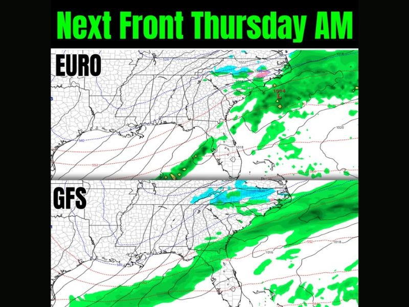
The newest model depictions place the front and associated precipitation near the Southeast coastline by Thursday morning, with both major forecast models clustering around a similar timeline. When EURO and GFS solutions align closely, it typically increases confidence in the overall pattern, even if exact rain and snow lines still shift.
The graphic highlights the front as the next organized weather maker after recent winter conditions, keeping the active pattern in place through the end of the week.
Rain Band Targets the Southeast While Coastal Low Develops Offshore
Both model snapshots show widespread precipitation covering portions of the Carolinas and coastal Mid-Atlantic, with a low-pressure system indicated offshore in the western Atlantic. That setup commonly supports an extended stretch of rain near the coastline while colder air filters in behind the front.
The rain shield also extends into parts of the Deep South, signaling a wet start to Thursday for many communities along and east of the I-95 corridor.
Mid-Atlantic Snow Chances Return as Colder Air Pushes In
North of the rain band, the model depictions show a colder zone supportive of snow stretching through parts of the Mid-Atlantic interior. While exact placement remains uncertain at this range, the pattern suggests that areas just inland from the coast could see wintry precipitation depending on how quickly cold air arrives and how the offshore low tracks.
This is not being framed as a single locked-in snowstorm yet, but rather a renewed opportunity for accumulating snow in a region already dealing with repeated winter disruptions.
Another Cold Shot Presses Into Florida With No Quick Warmup
Behind the front, colder air is expected to surge south again, reinforcing below-normal temperatures across the Southeast and into Florida. The forecast discussion tied to the graphic notes that a meaningful warmup may not arrive until next week, signaling continued winterlike conditions for a region that has already experienced multiple cold pushes this season.
With repeated fronts and limited recovery time between systems, residents are being urged to stay aware of forecast updates, especially for temperature-sensitive plans and travel.
For continued tracking of winter fronts, snow potential, and regional cold outbreaks, follow updates at WingsPNW.com.
Leave a Reply