
NEW YORK CITY, NEW YORK — After more than a week locked in true winter chill, New York City finally managed to break its streak of days stuck at or below freezing — but the broader region is still running colder than normal, and parts of Long Island didn’t budge above 32 degrees at all.
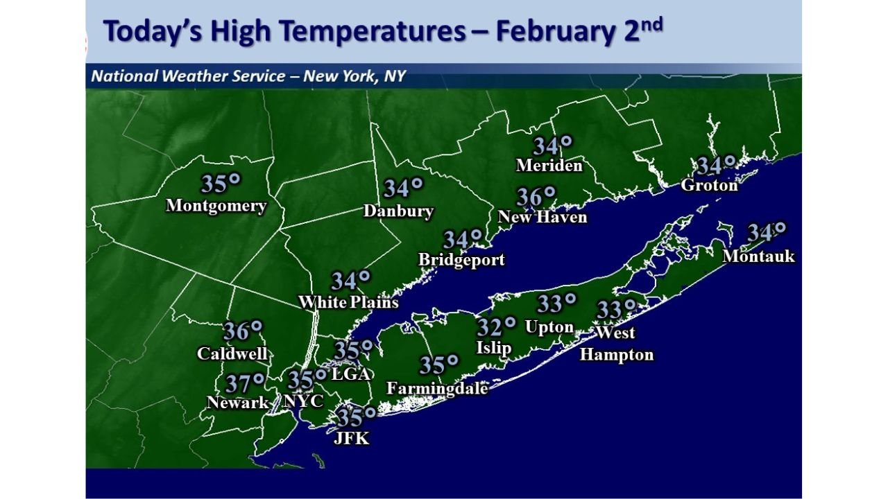
Data shared from the National Weather Service’s New York office shows Feb. 2 high temperatures clustered mostly in the low-to-mid 30s across the metro area, with NYC reporting 35°F. That’s a small but meaningful shift after a long run of cold, and it marks the warmest day since Jan. 23, 2026, when highs were reported in the upper 30s.
However, the “break” isn’t universal. The high at Islip was 32°F, meaning that location’s at-or-below-freezing streak is still ongoing, even as the city edges upward.
NYC Breaks the Streak, But the Air Mass Still Isn’t “Mild”
Even with NYC reaching the mid-30s, this is not a warm pattern for early February standards in the region.
The note accompanying the data stresses that temperatures remain below normal, with typical highs for this time of year generally in the upper 30s to lower 40s. In other words, the area has improved from “locked freeze” to “cold but slightly less harsh,” and that difference can still matter for daily life — especially for travel, outdoor work, and road conditions when overnight refreezing is in play.
Feb. 2 Highs: Metro Area Stays Stuck in the 30s
The map highlights how widespread the low-30s chill remained across the region:
- NYC: 35°F
- LaGuardia (LGA): 35°F
- JFK: 35°F
- Newark: 37°F
- Caldwell: 36°F
- White Plains: 34°F
- Bridgeport: 34°F
- Danbury: 34°F
- Meriden: 34°F
- New Haven: 36°F
- Groton: 34°F
- Montauk: 34°F
- Islip: 32°F
- Upton: 33°F
- Westhampton: 33°F
- Farmingdale: 35°F
- Montgomery: 35°F
The takeaway is clear: even where the freezing streak ended, the “warm-up” was limited — with many communities still topping out only a few degrees above freezing.
Why This Matters: Freezing Lines and Real-World Impacts
When highs hover between 32 and 37 degrees, small differences can have outsized effects:
- A 32°F high (like Islip) can keep surfaces colder longer, supporting lingering ice where it exists.
- A 35°F high (NYC, JFK, LGA) may slowly soften conditions during peak afternoon hours, but refreezing can still happen quickly after sunset.
- A 37°F high (Newark) can be enough to noticeably reduce slick spots — but only if skies, wind, and ground temperatures cooperate.
That’s why a “streak break” in the city doesn’t automatically translate to easier conditions everywhere — especially across Long Island and shoreline zones where temperatures can behave differently than inland suburbs.
A Bigger National Picture: East Stays Cold While the West Runs Hot
For WingsPNW readers, this snapshot of the New York metro reinforces a pattern that’s shown up repeatedly this winter: the cold has been more persistent in parts of the East, while large portions of the West have experienced a much milder-than-average season overall.
Even though this update focuses on the Northeast, it helps explain the “split winter” many people have noticed across the country — one region battling extended cold stretches, another dealing with a very different kind of winter.
What to Watch Next
The key question after a day like Feb. 2 is whether the region can build on this slight improvement — or if another push of colder air resets the freeze streak in places that only briefly climbed above 32.
If you’re tracking winter patterns from the Pacific Northwest and beyond, we’ll continue breaking down where the most stubborn cold is holding on — and where winter warmth is rewriting expectations.
What are you seeing where you live this season — more cold snaps, fewer, or just weird temperature swings? Share what’s happening in your area and join the conversation at WingsPNW.com.
Leave a Reply