
UNITED STATES — Forecast models are signaling a more active pattern next week, and meteorologists say the middle of February could deliver one or more spring-like systems as a trough ejects into the Central Plains. While it is too early to pin down exact storm track, snow totals, or thunderstorm placement, ensemble guidance is showing growing agreement on a setup that could divide the country into a northern snow zone and a southern corridor capable of storms.
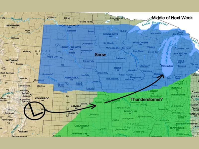
Ensemble Models Indicate a Central Plains Trough Midweek
Meteorologists monitoring multiple ensemble model sets say the key feature is a trough forecast to eject into the Central Plains in the middle of next week. That kind of pattern often creates a sharp boundary between colder air to the north and warmer, more humid air to the south, helping organize a widespread storm system.
Forecasters stress that this is an early broad-brush view, not a final snowfall or severe weather forecast, but enough agreement exists to flag next week as a higher-impact window.
Snow Zone Could Stretch From Nebraska Into the Dakotas, Minnesota and Wisconsin
The map’s shaded snow area covers a large northern tier, including much of Nebraska, South Dakota, North Dakota, and Minnesota, with snow potential extending into Wisconsin and portions of Michigan. This implies that colder air would remain well-established across the Upper Midwest while the storm system moves through.
For the northern zone, the primary risks typically include accumulating snow, blowing snow in stronger wind fields, and potential travel disruptions if timing lines up with weekday commutes.
Thunderstorm Corridor Highlighted From Oklahoma Through Missouri and Into Illinois
Farther south, the map highlights a broad corridor labeled for possible thunderstorms, stretching from Oklahoma across Missouri and into Illinois, with the green shading extending toward Indiana and parts of the lower Great Lakes region.
At this stage, the exact placement is still uncertain, but the pattern suggests warmer air could surge north enough to support rain and thunderstorms along and south of the storm track, especially near the boundary between the warm and cold air masses.
Why It’s Too Early for Exact Totals, But Not Too Early to Prepare
Forecasters caution that meaningful changes can still occur in storm track and temperature profiles, which can shift the rain-snow line by hundreds of miles. The same system could trend colder and bring more snow farther south, or trend warmer and push rain farther north.
Even with uncertainty, the large-scale signal is strong enough for residents across the Central U.S. and Midwest to start planning for a potentially disruptive midweek period, especially those traveling long distances.
What to Watch in the Next Forecast Updates
The next key updates will focus on how quickly the trough ejects, where surface low pressure develops, and how much warm air returns ahead of it. Those factors will determine whether the thunderstorm zone expands, where the heaviest snow band sets up, and which states see the sharpest impacts.
For continued tracking of national storm setups and how they evolve into local impacts, follow updates at WingsPNW.com.
Leave a Reply