Meteorologist Explains How Stubborn Cloud Deck Kept San Antonio Temperatures Lower Than Expected in Texas Forecast
TEXAS — A lingering cloud deck trapped along the Balcones Escarpment kept San Antonio temperatures several degrees cooler than surrounding areas on Saturday, creating a challenging forecast scenario that pushed daytime highs lower than expected.
Cloud Layer Became “Stuck” From Bexar to Comal County
According to the meteorologist’s analysis, the cloud deck functioned like a puddle pressed against the escarpment, slowing the natural mixing-out process that typically clears skies. With lower winter sun angles, the dense layer took longer to break apart, leaving much of San Antonio under cloud cover deeper into the afternoon.
This prevented the city from receiving the extra one to two hours of sunshine needed to reach the originally forecasted high of 77 degrees.
Surrounding Cities Warmed Into the Upper 70s and Low 80s
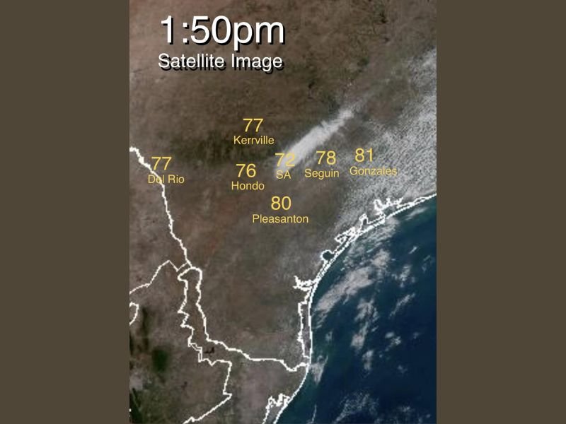
The satellite image from 1:50 p.m. shows the sharp temperature contrast across the region. While San Antonio held at 72 degrees, nearby cities saw significantly warmer conditions:
- Kerrville: 77°
- Hondo: 76°
- Seguin: 78°
- Gonzales: 81°
- Pleasanton: 80°
- Del Rio: 77°
These warmer readings were all located outside the persistent cloud deck, where sunshine allowed temperatures to rise efficiently.
Forecaster Acknowledges Missed Target and Explains the Challenge
The meteorologist noted that although the day remained sunny and warm for many locations, San Antonio’s cooler outcome demonstrated how local terrain and moisture patterns can disrupt even well-modeled forecasts. The Balcones Escarpment, in particular, is known for creating microclimates where cloud cover lingers unpredictably.
He emphasized the importance of transparency in forecasting, stating that he is comfortable acknowledging when a temperature target is missed and views these “wrinkles and challenges” as a natural part of the profession.
A Day That Showed How Quickly Local Conditions Can Shift
Saturday’s setup offered a clear example of how terrain-driven cloud behavior can influence temperature outcomes across short distances. While many communities warmed efficiently under clear skies, San Antonio’s stubborn cloud layer delayed warming long enough to keep the city below expectations.
For continued updates on Texas weather patterns and regional forecasting insights, stay connected with WingsPNW.com.