Heavy Sierra Snowstorm Expected As California Braces For Multiple Rounds Of Major Winter Weather Alerts
CALIFORNIA — Winter weather alerts have been issued across the Sierra as a strong atmospheric river threatens to bring significant snowfall late this weekend through Christmas week. Forecasters warn that multiple rounds of heavy snow will impact travel across the mountains, with totals ranging from 1 to 8 feet depending on elevation and timing.
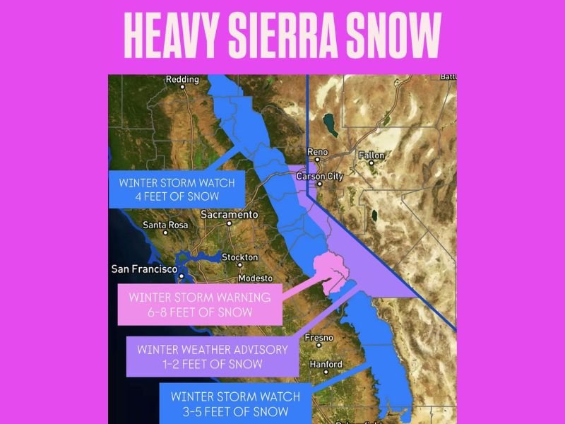
Winter Storm Warnings and Watches Cover the Central and Northern Sierra
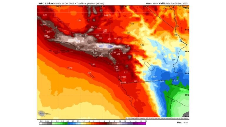
A Winter Storm Warning is now in effect for the central Sierra, where the latest projections indicate 6–8 feet of snow in higher elevations. The warning area stretches south of Truckee and toward Yosemite, marking the region expected to experience the most hazardous conditions and potential travel shutdowns.
Farther north and south of this zone, a Winter Storm Watch has been issued. Forecasts show the northern Sierra could receive about 4 feet of snow, while the southern Sierra is expected to see 3–5 feet as the atmospheric river sends moisture inland. These watches are expected to be upgraded as confidence in snowfall timing increases.
Winter Weather Advisory for Lower Elevations With 1–2 Feet of Snow
Lower-elevation Sierra foothill communities are under a Winter Weather Advisory, with totals of 1–2 feet of snow beginning Sunday afternoon. Even with smaller amounts, the advisory area may still face rapid accumulation, slippery roadways, reduced visibility and periods of heavy snowfall as cold air lowers snow levels.
Officials warn that drivers in these regions should prepare for delays, sudden whiteouts and chain controls, especially on secondary roads and mountain passes.
Christmas Week Storm Pattern Bringing Additional Hazards
A second system is projected to arrive early Christmas week, prompting an additional Winter Storm Watch for the Sierra. Forecast confidence is high that another round of heavy snowfall will impact the region shortly after the first storm exits.
Meteorologists expect back-to-back snowfall events, which could create deep snowpack layers, increase avalanche danger and produce widespread travel disruptions across I-80, US-50 and SR-88.
What the Snow Means for the Sierra and Surrounding Areas
With snow totals that could reach eight feet in the highest elevations, this series of storms has the potential to become one of the most impactful early-winter events in recent years. The snowfall will contribute positively to long-term snowpack levels but will also bring high-impact hazards including whiteout conditions, falling trees, power outages and extended pass closures.
Residents, travelers and holiday visitors are urged to monitor updated forecasts closely, limit high-elevation travel and prepare for shifting winter conditions as additional alerts are issued. For ongoing updates on winter weather affecting the West Coast, stay with WingsPNW.com.