
UNITED STATES — The Mid-Atlantic is facing one final surge of dangerous cold tonight into Monday morning, with wind chills dropping to zero or well below zero across large parts of Maryland, Virginia, West Virginia, and the Washington, D.C. metro area, before a brief warmup arrives later this week.
According to overnight data from the National Weather Service Baltimore/Washington, this will likely mark the coldest wind chill period of the season for many communities, prompting one last round of Cold Weather Advisories to be issued later today.
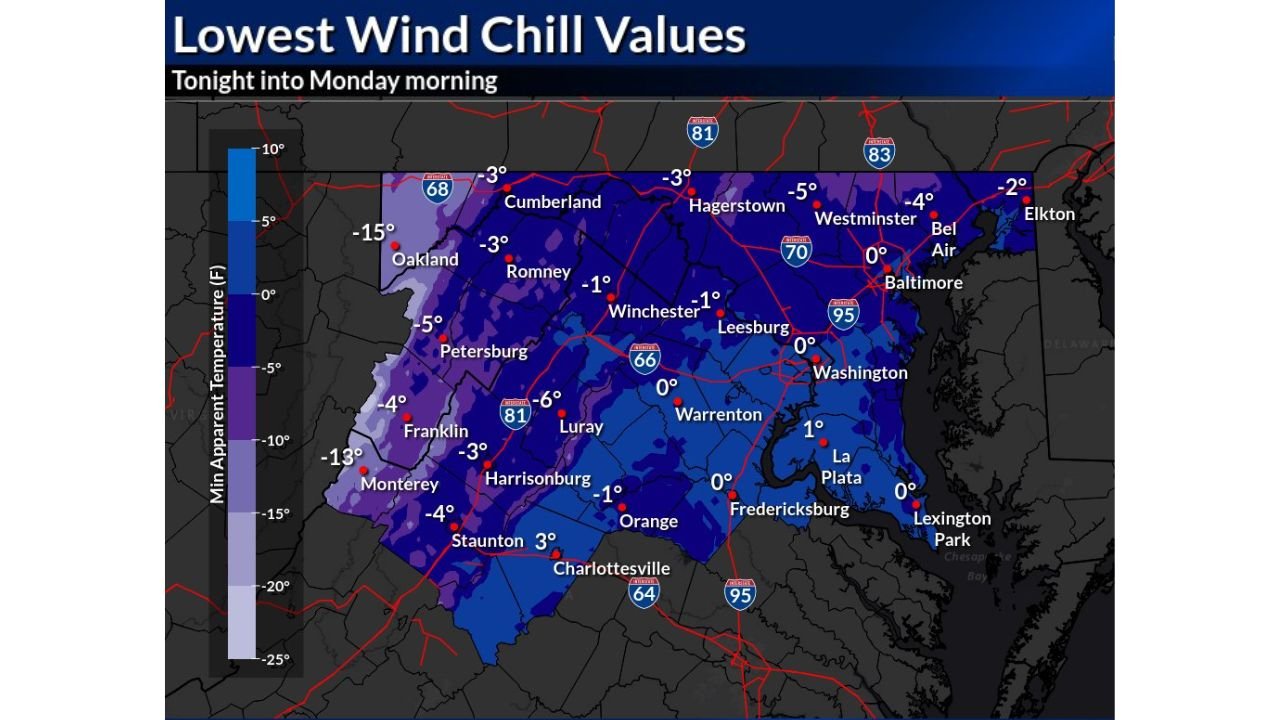
Coldest Wind Chills Focused in the Mountains and Interior Valleys
The most extreme conditions are expected across western Maryland, the Allegheny Highlands, and the central Appalachians, where wind chills will plunge deep below zero.
- Oakland, MD: Around –15°F wind chills
- Monterey, VA: Near –13°F
- Petersburg, WV: Around –5°F
- Romney, WV & Cumberland, MD: Around –3°F
These values are cold enough to cause frostbite on exposed skin in as little as 30 minutes.
Subzero and Near-Zero Wind Chills Reach the I-95 Corridor
Even areas closer to the coast will not escape the cold:
- Hagerstown, MD: Around –3°F
- Winchester, VA & Leesburg, VA: Near –1°F
- Baltimore, MD: Around 0°F
- Washington, D.C.: Near 0°F
- Fredericksburg, VA & La Plata, MD: Around 0–1°F
While not as extreme as the mountains, these readings are well below normal for early February and pose risks to anyone outdoors overnight or early Monday morning.
Why This Is the Last Cold Shot—for Now
Meteorologists say this is the tail end of a prolonged arctic air mass that has dominated the eastern U.S. in recent days. A brief moderation is expected during the first half of the week, allowing temperatures to rebound closer to seasonal levels.
However, forecasters stress that this is a short-lived warmup, not a full transition into springlike conditions.
Advisories Expected to Be Issued
The National Weather Service has indicated that Cold Weather Advisories will likely be issued later today for:
- Western and central Maryland
- Much of Virginia
- Portions of West Virginia
- Areas near and west of the I-95 corridor
Residents should be prepared for hazardous overnight conditions, especially in rural and mountainous locations.
Safety Reminders Ahead of Monday Morning
- Limit time outdoors overnight and early Monday
- Wear multiple layers, hats, gloves, and face coverings
- Bring pets indoors and protect exposed plumbing
- Check on vulnerable neighbors
While relief is on the way, tonight remains dangerous, and precautions are strongly advised until temperatures rise later Monday.
Stay with WingsPNW.com for continued Mid-Atlantic weather updates, advisory alerts, and coverage as the region transitions out of this intense cold spell.
Leave a Reply