
UNITED STATES — A surge of bitter Arctic air continues to grip the Northeast today, keeping daytime temperatures locked in the low to mid-20s across New York City, northern New Jersey, and much of Connecticut, while strong north winds push wind chill values into the single digits throughout the day.
According to National Weather Service data issued early Sunday, this cold air mass is accompanied by persistent gusty winds, creating dangerous cold exposure conditions despite sunshine in some areas.
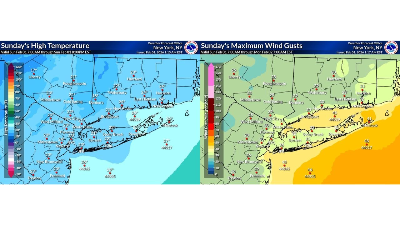
Temperatures Struggle to Rise Above the Low to Mid-20s
High temperature maps show widespread cold across the tri-state region, with many communities failing to climb out of the lower 20s even during peak afternoon heating.
Observed and forecast highs include:
- New York City: around 23°F
- Newark and northern New Jersey suburbs: 22–24°F
- Bridgeport and coastal Connecticut: 24–26°F
- Interior Connecticut locations: 21–23°F
- Hudson Valley and inland New York: upper teens to low 20s
Even along coastal Long Island and southern Connecticut, temperatures remain well below seasonal averages.
Gusty North Winds Intensify the Cold
While temperatures alone are cold, wind gusts are the bigger concern today.
Maximum wind gust forecasts show:
- 25–30 mph across much of New Jersey, New York City, and inland Connecticut
- 30–35 mph along Long Island and coastal Connecticut
- 40–45 mph possible over the coastal waters and barrier islands
These winds significantly amplify the cold, pushing wind chill values into the single digits for much of the region.
Wind Chills in the Single Digits All Day
With temperatures barely reaching the 20s and steady north winds, feels-like temperatures remain dangerously low.
Expected wind chill ranges include:
- Single digits across New York City, northern New Jersey, and Connecticut
- Low teens at best near the immediate coast
- Near zero at times in more exposed inland locations
Prolonged exposure can lead to frostbite and hypothermia, especially for anyone outdoors without proper winter clothing.
Travel and Outdoor Safety Concerns
The combination of cold temperatures and gusty winds may lead to:
- Hazardous conditions for high-profile vehicles, especially on bridges and open roadways
- Increased risk for cold-related health issues
- Rapid heat loss for anyone spending extended time outdoors
Residents are urged to bundle up, limit outdoor exposure, and secure loose objects that could be blown by gusty winds.
Cold Pattern Holds Firm
Forecast guidance shows little immediate relief from the cold, with temperatures remaining well below normal and wind chills staying harsh through the day.
While winds are expected to gradually ease overnight, another cold night is expected before any meaningful moderation arrives later in the week.
Stay with WingsPNW.com for continued Northeast cold weather updates, wind alerts, and temperature trends as this Arctic pattern continues to impact the region.
Leave a Reply