
UNITED STATES — Cold air remains firmly in place across the Ohio Valley today, but meteorologists say attention is now shifting toward a developing snow threat Tuesday into Tuesday night, as a weather system moves through the region with the potential to produce accumulating snowfall mainly south of the I-70 corridor and into northern Kentucky.
Forecast guidance released early February 1, 2026, indicates this will not be a widespread heavy snow event, but enough accumulation is possible in favored areas to impact travel, especially during the Tuesday afternoon and evening hours.
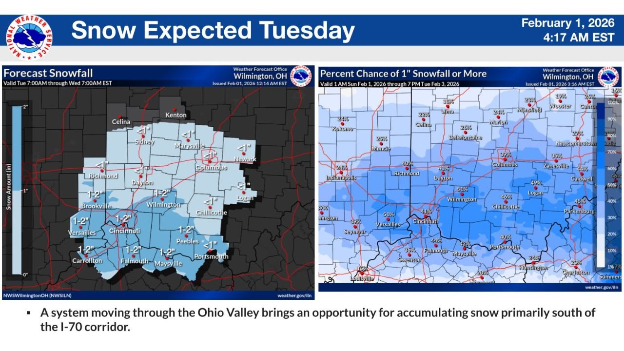
Where Snow Is Most Likely to Accumulate
Based on the latest snowfall projections, the highest confidence for accumulation is focused across southern Ohio and northern Kentucky, with lighter amounts north of I-70.
- Southern Ohio (south of I-70): A general 1 to 2 inches possible
- Cincinnati metro area: Around 1–2 inches, with locally higher totals in heavier bands
- Northern Kentucky: 1–2 inches, especially near the Ohio River
- Central Ohio (Columbus, Newark): Less than 1 inch, with some areas seeing little or no accumulation
- North of I-70: Snow chances decrease rapidly, with minimal impacts expected
These amounts are based on current forecasts and may shift as the system evolves.
Probability Maps Show Higher Confidence in the South
Percent chance guidance for 1 inch or more of snow reinforces the southward focus:
- 50–55% chance near Cincinnati, Wilmington, and Versailles
- 40–50% chance across parts of southern Ohio
- 20–30% chance or less north of Columbus and Dayton
This pattern highlights the importance of the storm track, which will determine where the sharper snow gradient sets up.
Why South of I-70 Is Favored
Meteorologists explain that the system is expected to track just far enough south to keep colder air locked in across southern Ohio and northern Kentucky, while slightly warmer air limits snow farther north.
Key factors include:
- Cold air already in place from recent arctic intrusions
- A fast-moving system that limits total snowfall amounts
- The sharp north–south temperature gradient near the I-70 corridor
Even small shifts in the track could still alter totals by a few miles in either direction.
Timing and Impacts
- Snow is expected to develop Tuesday, continuing into Tuesday night
- Impacts are most likely during evening travel hours
- Roads could become slick quickly where snow bands persist
While this is not expected to be a major winter storm, even light accumulation can cause problems given the cold ground temperatures.
Stay Tuned for Updates
Forecasters stress that details are still being refined, and snowfall amounts could change as newer data comes in.
Residents across southern Ohio and northern Kentucky should:
- Monitor updated forecasts
- Plan for possible slick travel Tuesday evening
- Allow extra time if commuting south of I-70
For continued updates, snowfall maps, and Ohio Valley weather coverage, stay with WingsPNW.com, where we track developing winter threats as they take shape.
Leave a Reply