
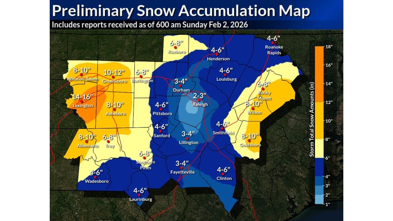
UNITED STATES — A newly released preliminary snow accumulation analysis reveals an unusually complex winter storm across North Carolina, where two separate snowfall maxima developed—one across the western Piedmont and Triad and another across the eastern Coastal Plain—while the Triangle region remained locked in a striking snowfall minimum.
The map, issued early Sunday morning by the National Weather Service Raleigh, is based on snow reports received through 6:00 a.m. Sunday, February 2, 2026, and highlights one of the sharpest snowfall gradients seen in recent Southeast winter storms.
Western Piedmont and Triad: Storm’s Primary Snow Core
The heaviest snowfall in the state was concentrated across the western Piedmont and Triad, where deep banding allowed totals to climb rapidly overnight.
- Lexington: 14–16 inches, the highest totals observed statewide
- Greensboro: 10–12 inches
- Winston-Salem: 8–10 inches
- Asheboro: 8–10 inches
- Albemarle: 8–10 inches
- Troy: 6–8 inches
These totals place portions of Davidson and Randolph counties into historic February territory, with snow depths rivaling some of the strongest cold-season events on record.
The Triangle: A Remarkable Snowfall Minimum
In stark contrast, the Triangle region—surrounded on all sides by heavier snow—experienced dramatically lower accumulations due to storm-scale subsidence and dry-slot intrusion.
- Raleigh: 2–3 inches
- Durham: 3–4 inches
- Chapel Hill / Pittsboro: 4–6 inches
This sharp minimum stands out clearly on the accumulation map, underscoring how small shifts in storm dynamics can dramatically change impacts over short distances.
Central and Southern Counties: Moderate but Disruptive Snow
Moving south and southwest of the Triangle, snowfall increased again but remained below the western maxima.
- Sanford: 4–6 inches
- Lillington: 3–4 inches
- Southern Pines: 6–8 inches
- Fayetteville: 3–4 inches
- Laurinburg: 4–6 inches
- Clinton: 4–6 inches
While not record-breaking, these totals were sufficient to cause widespread travel disruptions, especially where untreated roads remained snow-covered.
Eastern Coastal Plain: Second Snowfall Maximum Emerges
A second heavy snow axis developed across the eastern Coastal Plain, where colder air remained locked in longer than expected.
- Goldsboro: 8–10 inches
- Wilson: 8–10 inches
- Rocky Mount: 6–8 inches
- Smithfield: 4–6 inches
- Roanoke Rapids: 4–6 inches
This eastern maximum mirrors the western Piedmont pattern and is notable for producing near double-digit snowfall in areas that typically struggle to accumulate significant snow.
Why This Storm Was So Unusual
Meteorologists note that this storm will be remembered not just for its snowfall totals, but for its highly asymmetric structure:
- Two dominant snow maxima separated by a pronounced minimum
- Extremely tight gradients, with differences of 8–12 inches over short distances
- A classic example of deformation-band dominance paired with mid-level dry intrusion
Additional snow reports may still refine final totals, but the overall pattern is expected to remain unchanged.
What Residents Should Know Next
- Snow-covered secondary roads may persist where melting is slow
- Refreezing remains a concern during overnight hours
- Final verified totals will determine whether new local February records are set
This storm serves as a reminder that Southeast winter weather can be just as complex—and impactful—as events farther north.
For continued analysis, storm updates, and regional weather coverage, stay connected with WingsPNW.com and share your local snowfall reports with our team.
Leave a Reply