
UNITED STATES — A powerful winter storm has carved a historic snow swath across the Southeast, delivering widespread double-digit snowfall totals from the southern Appalachians through central North Carolina and into eastern Virginia, according to the latest National Weather Service snowfall analysis compiled from Local Storm Reports, COOP stations, and CoCoRaHS observers.
Updated early February 1, 2026, the analysis shows this storm already ranks among the most significant February snow events on record for many locations, with additional reports still being processed that could further adjust historical standings.
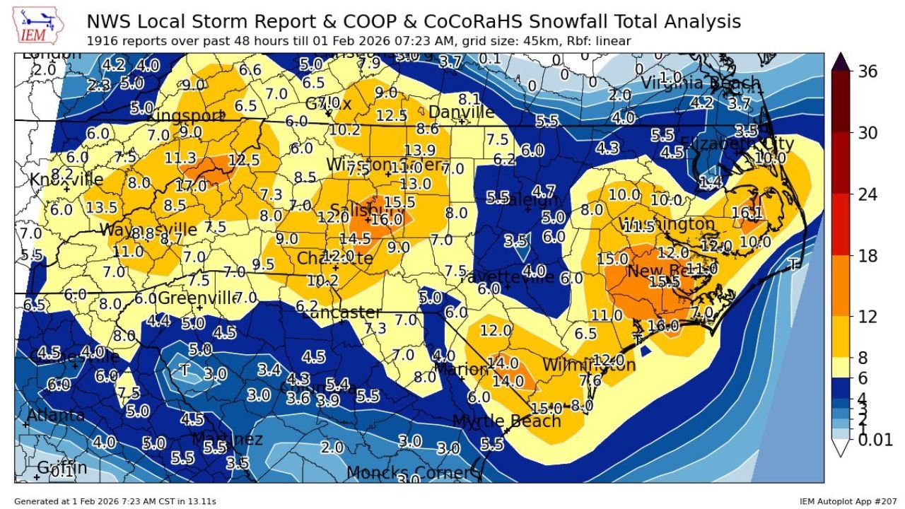
Central and Western North Carolina See the Heaviest Core
The heart of the storm set up across central and western North Carolina, where snowfall totals surged well beyond typical regional averages.
- Winston-Salem to Greensboro: Widespread 13 to 16 inches, with localized pockets exceeding 16 inches
- Charlotte metro: Generally 10 to 12 inches, with heavier bands north and east of the city
- Hickory, Statesville, and foothill communities: Commonly 12 to 17 inches, including one of the storm’s highest inland reports near 17 inches
- Asheville and surrounding mountain valleys: Mostly 7 to 9 inches, with higher elevations seeing locally more
The sharp gradient between heavy snow and lighter totals highlights how narrowly focused the storm’s deformation band became overnight.
Eastern North Carolina and Coastal Plain Pounded by Rare Heavy Snow
Snowfall increased again moving east into the Coastal Plain, where climatologically rare totals were observed.
- Raleigh-Durham area: Around 4 to 6 inches, sharply increasing just east of the Triangle
- Goldsboro to Wilson: 10 to 12 inches
- New Bern and surrounding coastal communities: 12 to 15 inches, with several reports near 15.5 inches
- Wilmington area: 10 to 12 inches, exceptionally high for a coastal February storm
- Myrtle Beach region: Roughly 14 to 15 inches, among the highest totals ever documented there
These totals place parts of eastern North Carolina and the southern Carolina coast into top-tier historical territory.
Virginia Snowfall Peaks South and Central, Drops Off North
Virginia experienced a strong north-south gradient, with the heaviest snow focused across southern and central sections.
- Danville area: Around 12 inches
- South-central Virginia: 7 to 9 inches common
- Northern Virginia: Generally 4 to 6 inches, tapering sharply northward
- Virginia Beach region: Mostly 3 to 5 inches, significantly lower than inland areas
The rapid decrease toward the Chesapeake Bay underscores the storm’s tight thermal boundary near the coast.
South Carolina: Lighter but Still Notable Accumulations
South Carolina remained on the southern fringe of the storm, but snowfall was still impactful.
- Upstate: Generally 6 to 8 inches
- Central South Carolina: 4 to 6 inches
- Southern Midlands: Mostly 2 to 4 inches, with isolated higher totals
While totals were lower than in North Carolina, many locations still experienced disruptive winter conditions rarely seen this deep into the Southeast.
A Storm That Will Rewrite Records
Meteorologists emphasize that 1916 snowfall reports were used in the current analysis, and additional data could still elevate some locations into new all-time February records.
This storm stands out not just for snowfall amounts, but for its geographic reach, bringing significant snow to mountain, piedmont, coastal, and even beach communities in a single event.
What Happens Next
- Roads remain hazardous in many inland and coastal areas
- Cleanup and power restoration continue across multiple states
- Final historical rankings will be confirmed once all reports are verified
Residents are urged to continue using caution as temperatures remain cold enough to prolong icy conditions.
Have photos, measurements, or local impacts from this storm? Share your experience and stay updated with continued coverage at WingsPNW.com, where we track major weather events shaping the nation.
Leave a Reply