California Faces Potentially Historic Christmas Week Rainfall as Southern California Braces for Widespread Flooding Risks
CALIFORNIA — Southern California is on track to experience one of the wettest Christmas weeks in recorded history, as a powerful and persistent Pacific storm pattern is forecast to deliver days of heavy rainfall across coastal and inland areas from December 23 through December 27, according to high-resolution precipitation models.
Forecast data shows exceptionally high rainfall totals for large portions of Southern California, with impacts expected to stretch from Santa Barbara County through Los Angeles, Orange County, and parts of San Diego County.
Historic Rainfall Potential for Los Angeles and the South Coast
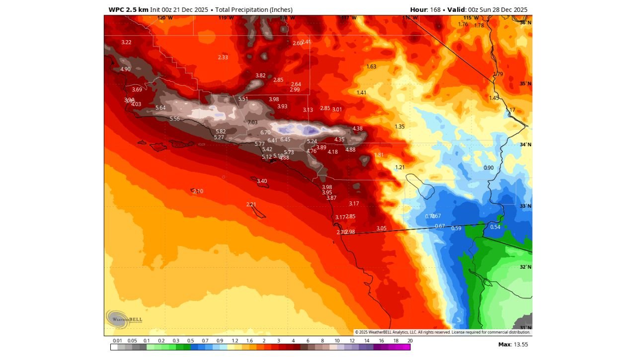
Weather models indicate that Los Angeles could receive approximately 6.4 inches of rain between December 23 and December 27, which would make this the wettest four-to-five-day Christmas period ever recorded in the city. The heaviest totals are focused along the coastal plain and foothills, where repeated rounds of moderate to heavy rain are expected.
This level of rainfall over a short time window significantly increases the risk of urban flooding, roadway ponding, and overwhelmed drainage systems, particularly in low-lying neighborhoods and areas with poor runoff.
Santa Barbara Could Reach a Full Year’s Rainfall by New Year’s
Even more striking totals are forecast farther northwest. Santa Barbara may approach or even exceed its typical annual rainfall total by New Year’s, based on cumulative precipitation projections shown in the model imagery.
The maps highlight widespread 5 to 7+ inch totals across coastal Santa Barbara County, with locally higher amounts possible in the nearby mountains. Such totals in late December raise concerns for mudslides, debris flows, and hillside instability, especially in burn-scar areas.
Mountains and Foothills at Elevated Risk
The most intense precipitation is expected to fall across the Transverse Ranges and coastal mountain slopes, where orographic lift will enhance rainfall rates. Several locations in the foothills and mountains of Southern California show model-projected totals exceeding 7 inches, with isolated spots potentially higher.
These conditions elevate the threat of flash flooding in canyons, fast-rising creeks, and debris flows, particularly during periods of heavier rain bands.
Storm Pattern Favors Prolonged Impacts
Unlike a single fast-moving storm, this setup involves multiple storm systems tapping into deep Pacific moisture, leading to prolonged rainfall over several consecutive days. Saturated soils will reduce the ground’s ability to absorb water, meaning flooding risks may increase as the week progresses, even if individual storms are not extreme on their own.
Coastal areas may also experience gusty winds, rough marine conditions, and localized power outages, especially where trees are weakened by saturated ground.
What Residents Should Prepare For
Residents across Southern California should be prepared for:
- Localized flooding and poor driving conditions
- Possible road closures and travel disruptions during the holiday week
- Mudslide and debris flow risks near hillsides and burn scars
- Rapidly changing conditions during heavier rain bands
Officials typically urge residents in flood-prone areas to monitor forecasts closely, avoid flooded roadways, and have emergency plans in place as conditions evolve.
Looking Ahead
While Southern California often welcomes winter rain, the magnitude and duration of this event make it unusual, particularly for the Christmas week timeframe. If forecast totals verify, this storm sequence will rank among the most impactful late-December rainfall events in Southern California history.
Residents should continue monitoring local forecasts and updates as confidence in timing and exact rainfall totals improves closer to the event.