
NORTH CAROLINA — North Carolina’s weather pattern shifts Tuesday with increasing clouds, slightly warmer temperatures, and a growing chance for rain showers later in the day and overnight. Forecasters say highs will be uneven across the state, with communities still holding onto deeper snowpack staying a couple degrees cooler than areas with limited snow on the ground.
Uneven Highs Expected as Snowpack Keeps Some Areas Cooler
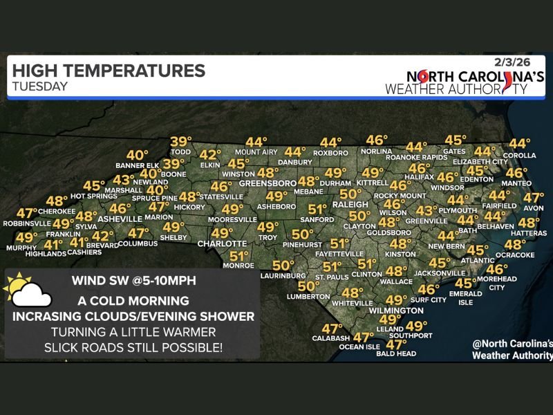
The temperature map shows a noticeable spread in Tuesday afternoon highs. Cooler readings remain in parts of the High Country and western mountains, where snowpack is more persistent. Some of the coolest values on the map include Boone near 39°, Todd near 39°, and Banner Elk around 40°, reflecting how leftover snow can keep daytime warming limited.
Farther east and south, where snow cover is reduced, temperatures climb into the upper 40s and low 50s, creating a sharp contrast across the state.
Where Temperatures Reach the Upper 40s and Low 50s
Many Piedmont and Sandhills communities are expected to push close to or just above 50 degrees. The map shows Raleigh around 50°, Durham near 49°, and Greensboro about 48°, with several nearby towns sitting in the upper 40s.
Across the southern tier, multiple areas are shown in the low 50s, including Fayetteville near 51°, Clinton around 51°, and Monroe near 51°, signaling the warmer side of the statewide temperature range.
Increasing Clouds With Evening Showers Arriving First in the West
Forecasters expect cloud cover to thicken through the day, with a few rain showers possible this evening across western North Carolina before activity expands east overnight. Importantly, the precipitation is expected to fall as rain, not snow, because temperatures should remain just above freezing for most communities.
Winds are expected from the southwest at roughly 5 to 10 mph, which can also help temperatures recover slightly during the afternoon.
Slick Roads Still Possible Despite the Rain Forecast
Even though the forecast favors rain, officials warn that slick roads may still be possible. Wet pavement combined with lingering cold air and shaded spots can produce isolated slippery areas, especially in higher elevations or locations where snowpack and meltwater remain on the ground.
Drivers are encouraged to stay cautious during the evening commute as showers begin and cloud cover prevents temperatures from dropping too quickly.
For continued updates on winter transitions, changing precipitation types, and statewide impacts, follow coverage at WingsPNW.com.
Leave a Reply