
UNITED STATES — Forecasters are pushing back on snow icons appearing in some weather apps for Tuesday night and Wednesday, saying the better signal is for cold but above-freezing temperatures and light rain, not accumulating snow. The shift is being framed as a better trend overall, with milder air expected to build later this week.
Snow Symbols in Some Apps Called “Not Accurate”
A forecast update noted that many viewers have asked why snow is showing up in app forecasts, but the current expectation is no meaningful wintry accumulation. While temperatures will be chilly, the air mass looks warm enough near the surface to keep most precipitation in liquid form, leading to rain instead of snow.
That means residents should prepare for wet roads and occasional slushy patches, but not a repeat of widespread wintry buildup.
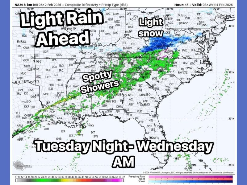
Light Rain and Spotty Showers Expected Tuesday Night Into Wednesday Morning
The updated precipitation outlook highlights light rain expanding across parts of the central and eastern United States, with spotty showers stretching from the Southern Plains into the lower Mississippi Valley and toward the Southeast.
A separate zone of light snow is shown farther north, but the key message for many communities in the rain band is that the system’s primary impact will be damp conditions rather than a snow event.
Cold Air Stays in Place, but Temperatures Remain Above Freezing
Even with the rain-focused forecast, temperatures are expected to stay cold, which can still create nuisance impacts. When light rain falls on very cold surfaces, it can create slick, messy spots, especially in shaded areas and on untreated roads early in the day.
Forecasters emphasized that it will be an uncomfortable stretch, but not cold enough in most places to trigger widespread pipe-protection measures.
Late-Week Warmup Could Push Highs Back Into the 50s
The more encouraging signal in the forecast is the rebound later in the week. The update points to temperatures recovering into the 50s, a noticeable thaw compared to recent cold.
Meteorologists said they will continue watching for changes, but the current trend favors a milder, wetter setup over another snow-producing system.
For continuing updates on shifting winter patterns and precipitation changes across the U.S., follow coverage at WingsPNW.com.
Leave a Reply