
OHIO — A new snowfall map updated Tuesday evening shows the highest confidence for impactful snow setting up south toward Cincinnati, even as forecasters continue to monitor uncertainty in how far north the snow shield ultimately reaches. The latest guidance suggests much of the region will see light accumulation, but a heavier band could form closer to the Cincinnati metro area.
Winter Weather Advisory Issued for Butler, Clinton and Warren Counties
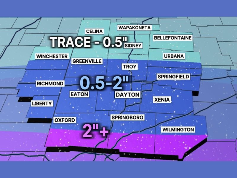
A Winter Weather Advisory has been issued for Butler, Clinton and Warren Counties from 7 a.m. to 10 p.m. Wednesday, where forecasters say the best chance of seeing 2 inches or more of snow exists. This is the area currently positioned nearest the most reliable corridor for heavier snowfall on the updated map.
Officials urge drivers in advisory counties to anticipate reduced visibility at times, slick untreated roads and a slower evening commute as temperatures remain cold enough for snow to accumulate.
Snowfall Map Shows Light-to-Moderate Totals Across Most Communities
The forecast map indicates widespread lighter snow for much of the viewing area, with totals generally ranging from a trace to 0.5 inch across the northern tier, while a broader zone farther south is projected to see 0.5 to 2 inches.
Cities and communities within the 0.5–2 inch range include areas around Dayton, including nearby locations such as Troy, Xenia, Springboro and Springfield, where light-to-moderate snow accumulation is possible depending on the exact placement of the snow band.
Heavier Snow Band Still Uncertain, but Likely Toward Cincinnati
Forecasters say the most important remaining question is where a heavier band organizes. While confidence is increasing that a more intense stripe of snow will develop, the exact placement remains uncertain and could shift north or south before the event begins.
At this time, the heaviest snow is considered most likely to form toward Cincinnati, which aligns with the advisory area and the forecast zone showing 2 inches or more along the southern edge of the map.
US-36 Line Marks Where 0.5–2 Inches Becomes More Likely
The forecast discussion notes that 0.5 to 2 inches of snow is possible from roughly US-36 and south, indicating that communities closer to the I-70 corridor and points south are more likely to see measurable snowfall compared to areas farther north.
Because snow bands can be narrow and highly localized, even small shifts in track can change totals significantly from one town to the next.
Commuters Urged to Watch for Updates Before Wednesday Evening
Forecasters advised residents to check for late-night and early-morning updates as new data arrives. The most impactful travel window is expected later Wednesday as snowfall rates increase and the event reaches its peak. For continued storm updates, snowfall tracking and regional impact coverage, follow weather reporting at WingsPNW.com.
Leave a Reply