
TEXAS — After a rapid warm-up that pushed parts of North Texas back near 70 degrees, another cold front is expected to arrive Wednesday with a disturbance, sending temperatures back down into the low to mid-50s and bringing a narrow window for rain — mainly southeast of the Dallas–Fort Worth area.
Wednesday Front Brings Cooler Air While Most Rain Stays Southeast of DFW
Forecast guidance tied to the front suggests that any measurable rain will likely favor locations southeast of DFW, while much of the Metroplex may see little to no precipitation. Even with limited rain coverage, the more reliable impact will be the cooler air mass pushing in behind the boundary, knocking highs down from the recent warmth to the 50s.
The pattern reflects a classic winter setup for North Texas, where fronts can deliver sharp temperature changes even when rainfall remains scattered.
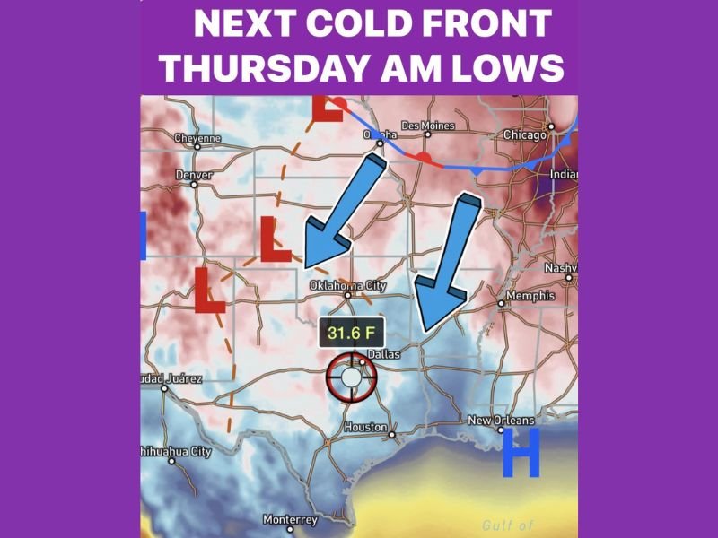
Light Freeze Possible Thursday Morning for Some Areas
By early Thursday, clearing skies behind the front could allow temperatures to drop quickly overnight. The outlook points to a light freeze for some, but not all, neighborhoods across North Texas, with the coldest readings generally expected in outlying and typically colder spots away from the urban core.
The guidance shared with the forecast discussion indicates temperatures near the freezing mark — including an example low near 31.6°F — but the forecast notes this cold snap is not expected to be severe enough to require dripping faucets for most households.
Big Temperature Swing Continues With a Fast Rebound Friday
Despite the midweek cooldown, the cold air is not expected to linger long. Forecasters say the region should “rocket” back into the 70s by Friday, continuing the back-and-forth winter pattern that has featured fast rebounds and short-lived cold shots.
This kind of quick whiplash can make planning difficult for drivers, commuters and families, especially when a brief freeze window follows a warm afternoon just 24 to 36 hours earlier.
What Residents Should Watch Over the Next 48 Hours
The key concerns in the short-term forecast remain timing and coverage: how much rain actually develops southeast of DFW Wednesday, and how quickly skies clear Wednesday night into Thursday morning. If clearing happens faster than expected, temperatures can fall more efficiently and expand the areas that briefly dip to freezing.
For continued tracking of shifting winter patterns and cold front impacts across the country, follow updates at WingsPNW.com.
Leave a Reply